
This is the land of the lək̓ʷəŋən, specifically the Songhees and ʷsepsəm (Esquimalt), and the W̱SÁNEĆ, made up of the W̱JOȽEȽP (Tsartlip), W̱SIḴEM (Tseycum), BOḰEĆEN (Pauquachin) and SȾÁUTW̱ (Tsawout), Peoples. These Nations are the living descendants of the families that have hunted and gathered on, and stewarded the land since time immemorial. The phrase 'time immemorial' is used when there is no longer a memory of the a point in time, as it occured so long ago. To learn more about the Creation stories of the W̱SÁNEĆ and the lək̓ʷəŋən People, we encourage you to learn from the respected storytellers of these Nations and participate in education opportunities held by the Nations.
James Douglas anchored off of Clover Point for the first time in 1842, stunned by the result of lək̓ʷəŋən Peoples stewardship of the land. Practices included controlled burns and food cultivation, especially of the starchy bulb of Camas, which when flowering, created seas of purple that Douglas compared to the Gardens of Eden. Douglas was not the first colonial captain to be impressed by the Camas meadows. Captain Vancouver had taken shelter on Tlchess, the lək̓ʷəŋən name for Discovery Island, in 1792 and described the landscape as enchantingly beautiful without any knowledge of the hard work by the female ancestors of the Indigenous family groups.
A map of Camosack or Camossung, the anglicized version of the Lekwungen word q̓əm̓ásəŋ, created in 1842 by cartographer Adolphus Lee Lewis who worked for the Hudson's Bay Company. The story of Camossung told by Elder Butch Dick, a member of the Songhees Nation, can be found here.

Following Douglas’ initial trip to Vancouver Island, in 1849, the Colonial Office of Britain permitted the Hudson Bay Company to settle and promote colonization of the island for 7 shillings a year for 10 years. One year later, the Douglas Treaties began to be negotiated between 14 Indigenous groups and James Douglas, representing the HBC. An important distinction to make is that Indigenous Peoples in southern Vancouver Island and around Port Hardy negotiated the terms of such treaties orally and the written document was created after the fact. Some signatories signed blank pieces of paper to which the terms of the agreement were written up later by the HBC. James Douglas provided a few materials such as cash, clothing and blankets and agreed that signatories and their descendants would retain their village sites and fields as well as the “liberty to hunt over unoccupied lands” and the right to “carry on their fisheries as formerly”. These terms were in no way upheld by the Hudson's Bay Company and later the government of Canada. For more information, explore this resource.

In the 20 years following the signing of the Douglas Treaties, Vancouver Island became increasingly settled especially during the peak of the Gold Rush. Initialized by American visitors celebrating July 4th, the American Day of Independence, large boat races called regattas were held and eventually moved to May 24th, Queen Victoria's Birthday. Races originally included Navy personnel, local clubs, Chinese boat races and Indigenous canoe races. These events became more segregated as time went on.

Encouraged by the ongoing regattas, boat builders Marshall Harry, SȾÁ,UTW̱ (Tsawout) band members and Edwin Underwood created a new canoe, a hybridization of local Indigenous designs and long English racing canoes. In 1876, it was in this hybrid canoe that a Songhees team won a 3.2km race in approximately 15 minutes.

In 1893, a local YMCA director began organizing swimming competitions in a log-enclosed swimming tank moored near Point Ellice. This was the beginning of a long history of swimming in the Gorge Waterway.

In 1904, the British Columbia Electric Railway Company bought 20 acres of land along the Gorge Waterway from the Hudson's Bay Company. This change of ownership kicked off the future of this land as a space of public enjoyment, recreation, development and pollution.

Funded by the BC Electric Company, Tramway Gorge Park was created in 1905 and boasted various amusement and recreation for the public. Visitors could take a tram from downtown Victoria directly to Tramway Gorge Park. Variety shows, a roller coaster, merry-go-round, concession, dance hall and boathouses contributed to the park's popularity.

Hayato Takata and Yoshitaro Kishida, two prominent figures in the Victoria Japanese-Canadian community, raised $5,000 in hopes of opening a Japanese Tea Garden in Tramway Park in 1906. Kishida's father, a professional gardener in Japan, designed the grounds and teahouse. The Japanese Tea House was extremely popular in the following three decades.

A drainage system was installed, in 1912, that emptied directly into the Gorge above the popular swimming spot at the Free. Pollution increased in following years as industrial development and septic tank runoff intensified.

In 1913, the 7th Annual BC Amateur Swimming Championships were held at Gorge Beach, a very popular swim spot especially into the 1920's. The creation of the Victoria Amateur Swim Club and the two story bath pavilion known as the Free indicate the popularity of swimming in the Gorge at this time.
Originally built in 1917 as a railway bridge to facilitate the unloading of logs from Vancouver Island's logging industry, the Selkirk Trestle enabled logs to be pushed off trains directly into the Gorge. Tugboats then transported the logs to the nearby pulp mill. Today, it serves as a segment of the Galloping Goose Trail, popular for cycling commuters and recreational runners and walkers of all speeds. Constructed from fir and hemlock, this 300-meter-long trestle includes a movable middle section that can be raised to allow tall ships to pass underneath.

The Gorge Waterway became part of the Victoria Migratory Bird Sanctuary to preserve important wintering habitat for millions of birds on their annual migrations in 1923. The Friends of the Victoria Harbour Migratory Bird Sanctuary celebrated 100 years of the VHMBS in 2023. Victoria is the birding capital of Canada!

In 1938, the Gorge was closed to swimming after a joint inspection of water quality by the City of Victoria and the Municipality of Saanich found the waterway polluted.

The pollution in the Gorge was linked to typhoid outbreaks in 1939, further degrading the reputation of the once pristine waterway. Before swimming in the Gorge, check the beach advisories provided by Island Health to ensure the water is safe to swim in.

During World War II, the Takata family, along with all people of Japanese descent in BC, were forced into internment camps, leaving their property to be looted and destroyed in acts of anti-Asian racism by local residents in 1942. The tea gardens were abandoned until almost three decades later.

Led by Victoria Alderman and Geoffery Edgelow, the Gorge Waterway Improvement Association (GWIA) began to clean up the waterway in 1954. In partnership with the City of Victoria and the Township of Esquimalt, septic outflow was significantly reduced by the addition of sewer systems between 1956 and 1958.

Due to cleanup efforts by the GWIA, the City of Victoria and the Township of Esquimalt, the Gorge Waterway was declared safe to swim in once again in 1958. The map below compares natural greenspaces with developed spaces in the mid 50's. The history of the Gorge shows how susceptible waterways are to an increase in impervious surfaces.

In 1958, funded by the Victoria Kinsmen Club, Kinsmen Gorge Park officially opened and a portion of Gorge Creek was dredged out to create a concrete salt water pool. This pool was chlorinated due to concerns about water quality and flushed untreated back into the waterway at the end of the season.

Swimming continued despite growing concerns of water quality due to increased development along the Gorge and lack of suitable sewage treatment infrastructure in 1968.

In 1990, the Gorge Waterway Action Society was created. Founded by a group of concerned community members, the Gorge Waterway Action Society's mission was to protect, restore and improve the Gorge Waterway. The Gorge Waterway is an important ecosystem in the middle of a highly urbanized environment, indicating the need for continued community outreach and environmental education.

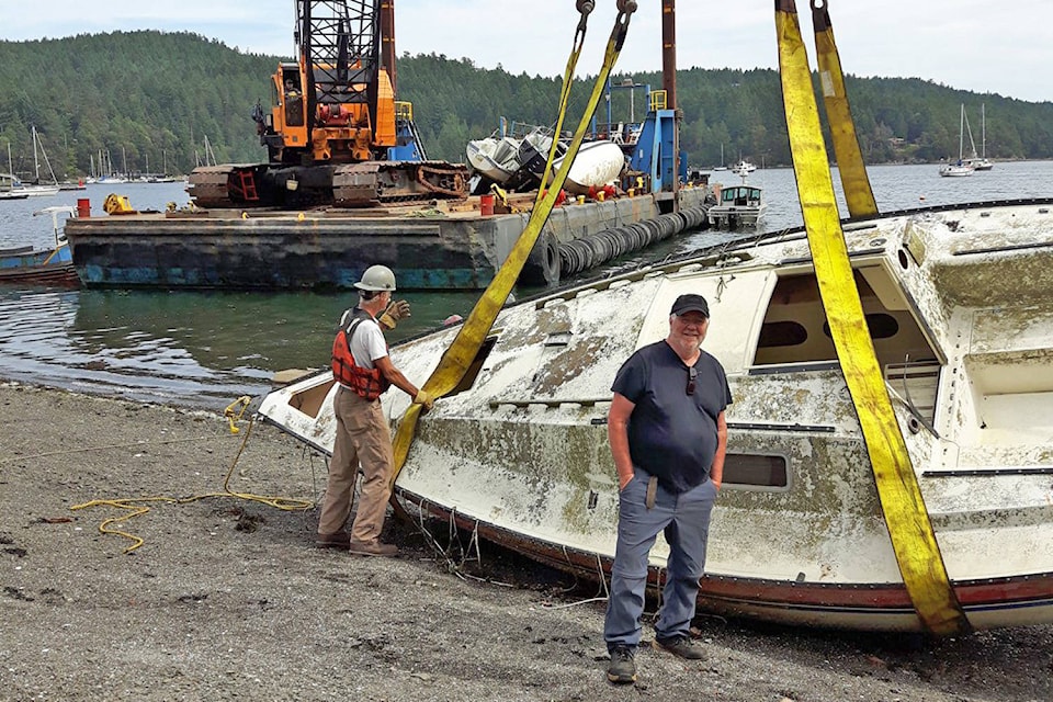
After urban development, poor waste management and lack of awareness, the Gorge again became incredibly polluted throughout the 70's and 80's. In 1994, John and Wesley Roe, a father-son duo started removing debris from the Gorge in an effort to address the pollution. "We pulled out every household item you can think of: microwaves, couches, beds, lots of broken glass, shopping carts" said Roe when cleanups started gaining momentum. John is still an active part of Gorge cleanups to this day.
By 1995, GWAS was made up of 175 volunteers dedicated to restoring the Gorge and building partnerships with the Township of Esquimalt, the City of Victoria, the Province of BC and other environmental NGOs. The organization released a report detailing members' hopes for the Gorge Waterway in the future, specifically the continous pollution.
Inspired by the cleanup efforts initiated in 1994 by the father-son duo, a core group of volunteers registered the Veins of Life Watershed Society as a non-profit with the goal to restore the watershed.

After extensive efforts by various non-profit groups, concerned community members and dedicated volunteers, the Gorge was given a clean bill of health in 2000 and swimming is once again safe.
As part of a major restoration project in 2005, the culvert that contained Gorge Creek underground for multiple decades was removed and Gorge Creek was allowed to flow freely into channels that accommodate tides, native plants and terrestrial species.

The creation of the settling ponds was a key feature of the 2005 daylighting of Gorge Creek. Approximately 1/3 of the run-off from the Township of Esquimalt comes through this culvert, bringing with it many pollutants from roads and ditches. Most of the flow is diverted into the upper pond where it slows for sediment to settle out. Cattails, sedges, and rushes in and around the pond help to filter contaminants. The lower pond creates habitat for waterfoul, forage fish and insects.

In partnership with the World Fisheries Trust and the Township of Esquimalt, the Kinsmen pool concession was transformed into the Gorge Waterway Nature House, a place of outreach, education and community gatherings in 2008.

In 2009, the Township of Esquimalt refurbished the Japanese Tea Gardens, installing a traditional Japanese entry gate and rejuvenating the gardens to their former glory under the care of the Takata family. In October of 2009, the Township hosted an official re-opening ceremony including a Buddhist garden blessing and performances by the Uminari Drum Group and the Furusato Dancers.

The World Fisheries Trust collaborated with the Capital Regional District of Victoria (CRD) on a project to safeguard Olympia Oysters impacted by the Craigflower Bridge Replacement Project. These oysters were relocated from the bridge site to two designated oyster shell reefs located at Christie Point and Esquimalt Gorge Park in 2014.

Organized by the Esquimalt and Songhees Nations and the Greater Victoria Harbour Authority in 2015, 5 Nations participated in the first war canoe races held in the Inner Harbour in over 100 years.

The Nature House became fully operated by the Gorge Waterway Action Society in tandem with the creation of the Nature Interpreter program in 2016. The Nature Interpreters provide environmental education for park visitors, develop activities for school visits and organize outreach events.

GWAS began restoration in Sherwood Forest in 2016. Sherwood Forest is the woodland East of the Nature House that hosts many restoration projects to support wildlife and forest health. Examples include invasive species removal, soil testing and the planting of native species with the hope of creating a forage food forest.

In 2017, three 350-pound hollow concrete artificial reefs (reefballs) were introduced into the Gorge, featuring large holes designed to facilitate water flow and promote oyster settlement, offering them a habitat above muddy substrates.

GWAS expanded its impact with the creation of the Restoration Program in 2017, followed by the Biology Program in 2018, Indigenous Youth Program in 2022 and Climate Interpreter Program in 2023. The Nature House is the hub at which staff and community members take part in restoration events, biological monitoring and environmental education events. Check out the species we encounter on our iNaturalist!

The Indigenous Youth Program Stewardship Site was designed in 2020 as a place for the Esquimalt and Songhees Nations to gather, engage with, and learn about culturally significant plants. These two sites are continually cared for by Indigenous youth and GWAS staff.

The pollinator meadow is a 125 meter squared meadow that hosts at least 35 native plant species and many different pollinators, initiated in 2020. GWAS staff conduct both biophysical and pollinator surveys to better understand how to support native pollinators as they become more endangered.

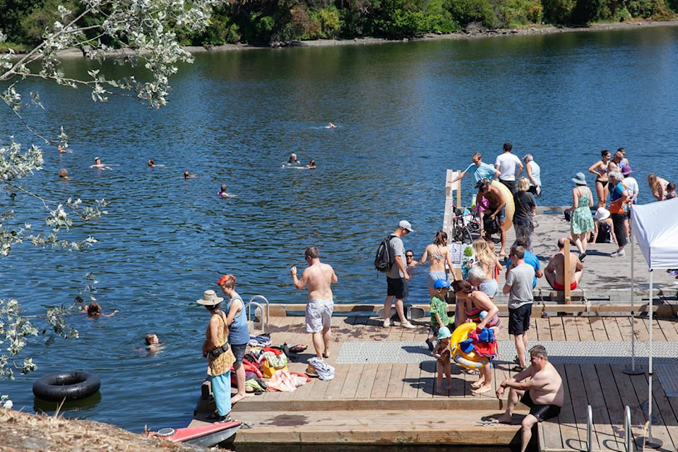
In mid-July 2022, Aryze Developments launched a floating public swim dock featuring a Japanese katsura tree, positioned near the Banfield public dock. In 2022, the City committed $300,000 to construct another swimming platform and install buoys to designate a protected swim zone. In 2024, further enhancements were established, such as a life-jacket loaner station, anchored buoys for a recreational swimming area, and additional swim steps to improve accessibility and safety.

Eelgrass is a keystone species which grows in shallow saltwater areas. Microorganisms such as algae and bacteria grow on the surface of the eelgrass leaves, which provides food for many marine organisms. Monitoring of the health of eelgrass in the Gorge was initiated in 2022 and continues annually.
Since 2022, GWAS has participated in the Department of Fisheries and Oceans’ European Green Crab Monitoring Project. European green crabs are a destructive invasive species that removes eelgrass very efficiently, destroying habitat for everything else in the Gorge. Unfortunately, teams caught adult European green crabs in the Gorge for the first time in August 2024 through the monitoring program. GWAS is working with the Department of Fisheries and Oceans and Peninsula Streams Society to remove as many as possible before the problem worsens. To prevent the spread of European Green Crabs, make sure to clean, drain, and dry off any watercraft according to BC Invasives.

A toxic chemical shed by tires, 6-PPDQ is particularly lethal for salmon species. In an effort to understand the concentration of 6-PPDQ in Gorge Creek, GWAS has been testing annually in partnership with BC Conservation Foundation and VIU since 2023.

At the mouth of Gorge Creek and flowing into the Gorge Waterway, the restored salt marsh is home to critically rare habitat and unique vegetated species. Since 2022, GWAS has removed invasive species, planted native species, stabilized banks and conducted annual biophysical surveys to continue care in this ecosystem.

Beginning in 2023, GWAS staff began to monitor amphibian presence in Esquimalt Gorge Park to aid in future restoration, habitat enhancement and understanding biodiversity in the park. The Northern Pacific Treefrog is the species of focus in this monitoring project, which is ongoing.

Thank you for exploring the flowing history of the Gorge Waterway with us. Keep in mind that this map is incomplete at this time, leaving room for an ongoing conversation. Much like the process of creating this map, we hope that interaction with this map is iterative, inviting you to come back to it and dive deeper each time. Think about what you will do with this information, if that means participating in weekly restoration , signing up for a Songhees Tour or getting involved in Land Back iniatives.